
The Colorado River’s flows are drastically over allocated and an 18-year drought from climate change makes the $2.24 billion Lake Powell Pipeline an extraordinarily risky investment for Utah taxpayers. Under new water shortage agreements, California, Arizona and Nevada are preparing to walk away from an astonishing 533,000 acre-feet of their Colorado River water supply.1 But Utah is recklessly proposing to divert another 86,000 acre-feet out of the river, as if 30 million people downstream won’t notice or care.
The Risks of the Lake Powell Pipeline
A Drying Watershed
As reservoir levels plummet, drought conditions persist, and the effects of climate change ramp up throughout the Colorado River Basin, it’s clear there isn’t enough water to go around. Over the last 20 years, the Colorado River’s flows have declined as mountain snowpacks have diminished in the headwaters of the basin. The historic multi-state agreement that divides up the river’s flows among seven states, Mexico and Indian Tribes treats the River as though there is 16.5 million acre-feet of water that can be diverted out annually. This isn’t the case.
Numerous studies conducted by credible research institutions, local, state, and federal water supplies, and independent scientific organizations, which have been published consistently in peer-review journals and other publications, demonstrate widely that climate change has reduced the flows of the Colorado River, and will continue to do so. A review of 800 peer-reviewed papers by the Western Water Assessment shows that most scientists expect that natural flows in the Colorado River will decrease 10% to 20% in the next few decades. The Bureau of Reclamation predicts that even a small decline, just 9%, will cause a 3.2 million acre-foot water demand-supply imbalance. There is no room for additional water diversions like the Lake Powell Pipeline in the drying Colorado River Basin.

Not Enough to Go Around
The Colorado River Compact divides the flows of the river among the 7 U.S. states, Mexico and Indian Tribes based on a total of 16.5 million acre feet. But the 30-year average shows there is actually just ~11 million acre-feet of water in the river, and this average is continuing to decline as air temperatures increase.
Water Supply Cutbacks
Recent modeling of the Colorado River’s flows by the Bureau of Reclamation paints a grim picture for millions of Lower Basin residents. The Bureau forecasts that elevation levels in Lake Mead will most likely remain below 1,090 ft over the next two years, where mandatory cutbacks for downstream water users will be enforced. The same Bureau report forecasts a 90% chance of Lake Mead dropping below crucial shortage levels in the next two years.
Unless drastic measures are made to reduce water use in the basin and abandon antiquated diversion projects that push the Colorado River Basin into further imbalance, the future of the Basin looks grim. Residents will be forced to abandon their water supplies and grapple with continued shortages for years to come. Utah must begin to recognize and adjust to this reality, embrace conservation practices, and work collaboratively with other states to ensure the future of the Colorado River and the water supply for 40 million residents.
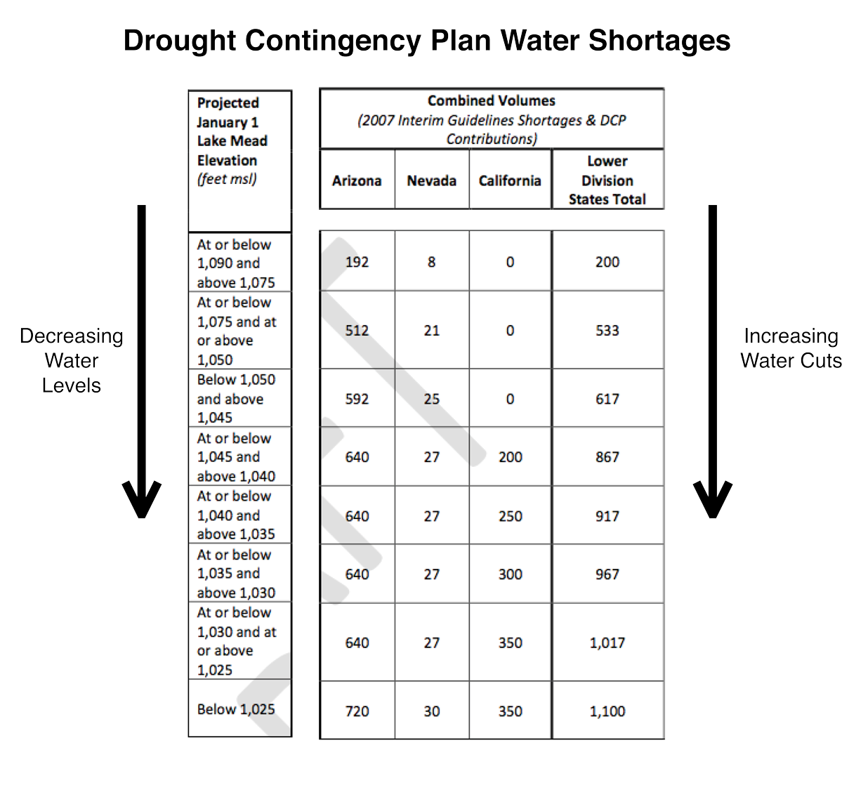
The table shows how much water the Lower Basin states have agreed to go without as part of an unprecedented Basin-wide drought agreement.
To begin, Arizona and Nevada are preparing to walk away from 533,000 acre-feet of their Colorado River water supply.3 Additional cutbacks in the Lower Basin will follow, as the level of Lake Mead continues to drop. There simply isn’t enough water to go around.
Water Cutbacks Will Increase As Reservoir Levels Drop
Recent modeling of the Colorado River’s flows by the Bureau of Reclamation paints a grim picture for millions of Lower Basin residents. The Bureau forecasts that elevation levels in Lake Mead will most likely remain below 1,090ft over the next 2 years, where mandatory cutbacks for downstream water users will be enforced.4

The Bureau of Reclamation forecasts a 90% chance of Lake Mead dropping below crucial shortage levels in the next two years.
Reductions in water deliveries are a bitter pill for Lower Basin water users to swallow, especially when new diversions like the Lake Powell Pipeline are being proposed for upstream communities that don’t need the water. Residents of Washington County use more than twice as much water per-person as the average American, because their tax collections lead to the cheapest water rates in the American West.
Yet surprisingly, when faced with criticism over the lack of need for the Lake Powell Pipeline, spending advocates in Utah claim we should build it anyway and use our share of the Colorado River before other states take it. Utah is entitled to a percentage of the Colorado River’s flows, but that doesn’t mean we are guaranteed a specific quantity. That’s why the water may not really exist for the Pipeline and the river’s flows will only continue to diminish as air temperatures rise.
Water Flow Declines In Upper Basin States
Like Lake Mead, Lake Powell is also at historically low water levels and just 75 feet above the water level were hydropower production is threatened. The Lake Powell Pipeline will take even more water out of the Colorado River and hasten the decline of water levels in Lake Powell, accelerating the timeframe for when the reservoir stops generating electricity. The Upper Basin States’ Drought Contingency Plan makes it clear that water leaders are worried about declining flows into Lake Powell. Several water supply forecasts show how close we are to Lake Powell water levels dropping below the minimum level needed to generate hydropower at Glen Canyon Dam.
The graph below by Hydros Consulting Inc. shows a hypothetical multi-year drought where Lake Powell water levels drop so low that hydropower generation becomes impossible. These consultants ran a hypothetical analysis looking at three droughts that occurred in the last 30 years: the 1988 drought; the 2001 drought and the 2012 drought. All three projections show that if we experience any of these three droughts again starting in 2019, Glen Canyon Dam will not be able to generate electricity and $180 million in revenues will dry up. This will strip funding from science and river management and raise power costs for tribes, cities and others all over the southwest.

The graph below was commissioned for the CRWCD Board. These consultants ran a hypothetical analysis looking at three droughts that occurred in the last 30 years: 1988 drought; the 2001 drought and the 2012 drought. All three projections show that if we experience any of these three droughts again starting in 2018, Glen Canyon Dam will not be able to generate electricity.
Upper Basin states like Utah aren’t immune from water shortage impacts on the Colorado River. As air temperatures have increased due to climate change, diminished mountain snowpack and changing precipitation patterns have reduced flows in the Colorado River, which, as mentioned above, are predicted to decline 10 - 20% by mid-century. The burden of diminished Colorado River flows resulting from climate change will be felt most heavily by Upper Basin states.
This is because the Upper Basin is required to deliver an average of 7.5 million acre-feet of water to the Lower Basin every year regardless of how much water flows into Lake Powell. Therefore, climate change caused flow depletions will eat away at the Upper Basin’s water supply, not the Lower Basin’s.
In fact, the Bureau of Reclamation predicts that even a modest decrease in Colorado River flows (9%) will result in the Upper Basin failing to deliver the required 7.5 million acre-feet to the Lower Basin every 4 to 5 years.6 In other words, the Bureau predicts that there will not be enough water in the Colorado River by mid-century to meet both the Upper and Lower basin’s needs. However, since the 1922 Colorado River Compact protects the Lower Basin’s water supply, only the Upper Basin will really feel the full pressure of this water shortage.
Are Lower Basin Water Users Opposed to the Lake Powell Pipeline?
The Lake Powell Pipeline faces unprecedented opposition from an incredibly diverse and robust coalition. In a historic first, a coalition of state water agencies, large water suppliers, and Governors’ representatives of Nevada, Arizona, California, Colorado, Wyoming and New Mexico authored a letter to the Secretary of the Interior asking them to halt Utah’s controversial Lake Powell Pipeline. The letter is a demonstration of how out of touch Pipeline proponents have been in understanding the projects impacts to the water supplies of the entire Colorado River Basin.
In addition to the Six States and water authorities, over a hundred small businesses in Nevada and Arizona signed on to a joint letter urging the Bureau of Reclamation to reject the Pipeline. This astonishing array of businesses and community leaders expressed serious concerns stating:
“Our business and communities will acutely feel the impacts of the Lake Powell Pipeline for generations to come. We are already struggling to grapple with the new reality on the river and the Lake Powell Pipeline will further jeopardize our economic future.”
The Lake Powell Pipeline was also heavily opposed by 14 other organizations from across the American West who signed on to the URC’s comments. Another sign that organizations from around the country recognize this Pipeline is fatally flawed.
The public is beginning to see through the Division of Water Resources and Washington County Water’s misinformation campaign. Pipeline proponents are going to work harder than ever to advance this fiasco, but we must continue to keep up the pressure! Call your legislators, write a Letter to the Editor in your local newspapers, and help us stay vigilant. With your help, this is a fight that we can, and we will win.
Citations
Agreement Concerning Colorado River Drought Contingency Management And Operations, Final Review Draft. Table 1 - DCP Contributions and 2007 Interim Guidelines Shortages by State, 10-5-2018
US Bureau of Reclamation. Lake Powell Unregulated Inflow. Water Year 2019 Forecast. https://www.usbr.gov/uc/water/crsp/cs/gcd.html
Agreement Concerning Colorado River Drought Contingency Management And Operations, Final Review Draft. Table 1 - DCP Contributions and 2007 Interim Guidelines Shortages by State, 10-5-2018
ADWRe and CAP Briefing on Lower Basin Drought Contingency Plan, June 28, 2018
US Bureau of Reclamation. Accessed 12/18/2018 https://www.usbr.gov/uc/water/crsp/cs/gcd.html
Udall, B. and J. Overpeck (2017), Hot Drought: The twenty-first century Colorado River hot drought and implications for the future. Water Resources Research, 53, 2404– 2418, doi:10.1002/2016WR019638.
Colorado River Compact of 1922. Article III(a)
Utah Board of Water Resources. Lake Powell Pipeline Water Needs Assessment: Demand and Supply Update Public Filing to FERC. Page 3.1.3. 11/16/2018